

Tips and Conditions - March 21st 2009
This weeks tips and snow report from Henry
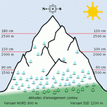
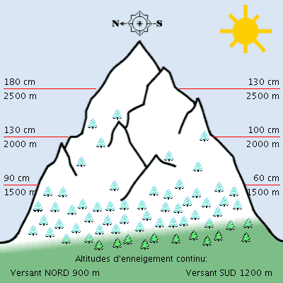
Snowpack March 21st 2009.
SPRING SKIING
Understand the 'melt-freeze cycles' and have fun with spring skiing! Off-piste spring skiing is one of the best things that the Northern French Alps has to offer. With lift access to all slope orientations: north, east, south and west, you can get on it with little effort.
Melt-freeze Cycles
Once the new snow melts during the day and then freezes at night (1 melt-freeze cycle) a few times in succession after a snowfall, the top snow layer begins to form a crust that gets deeper and stronger after each melt allows free water to drip down and re-freeze during the night. Any given 'melt-freeze' layer becomes stronger with each cycle of melting and freezing due to the deeper penetration of each melt during the day, which then adds more depth to the potential frozen layer at night.
If untouched, the top of this frozen layer is smooth and solid first thing in the morning, then it becomes progressively softer as the warm sun and increased temperatures melt it as the day goes by. This process starts on east faces because they get the sun first thing in the morning, then south, then west (north faces at 2500 metres don't normally get a melt freeze layer on them until late April due to lack of sun). For good skiing!
The trick is, after a couple of good melt-freeze cycles have created a solid layer on a slope, you need to get on that slope when the snow surface is smooth and solid with only 2 or 3 cm's of soft melted snow on top (these are generally slopes that have been in the direct sunlight only for an hour or so e.g. an East facing slope at 9 or 10). Then you need to get off those slopes when the snow surface begins to get too soft and mushy or you'll start breaking through, which is dangerous for your knees. AND the slope may be unstable due to all the melting - then avalanches can be a problem.
In sum:
After a solid melt-freeze layer has formed and there has been a good melt during the day, it needs to freeze well the night before; the ideal is a cool clear night with minimums of -2 degrees (or lower) at 2000 m. This will allow the melted parts of the layer to freeze solid again from that altitude up. Then, in the morning, you look to get on the east facing slopes first thing, 9 AM, because the sun rises in the east and therefore those slopes get the sun first. Then you move to south facing slopes, then west. Do this right and get some of the best skiing of the season.
Aside from a night that is not cool enough, the only thing that gets in the way of great spring skiing is the nasty ruts in the snow that people leave behind because they either ski spring snow slopes (slopes that get lots of sun in spring: E,S and W) before the melt-freeze layer has formed or they ski the slopes too late when they are too soft and mushy.
Tip of the week:
If you have any questions about the timing of good spring skiing, just ask any off-piste guide or instructor around town. They will be happy to explain because their quality of skiing depends on people skiing it right!
Have Fun, Be Safe! - Henry and the HAT Team
Avalanche safety bulletin
N73200311
BULLETIN FOR ESTIMATING THE RISK OF AVALANCHE
de SAVOIE valid outside of marked trails and open FOR SATURDAY 21 MARCH 2009 (written on Friday, 20 March)
ESTIMATE OF RISK UNTIL SATURDAY EVENING:
In ALL MASS Savoy: LIMIT RISK - Level 2.
WEATHER OVERVIEW UNTIL SATURDAY EVENING:
Still a few outbursts of Piedmont cloudy early in the night, then a few Cumulus afternoon. A little Foehn / Lombarde early night along border. Then Bise North-East is accelerating again and blows very hard day in high mountains and also lower in morning Beaufortain Maurienne in the West. Isotherme 0 ° C to 600 and 1200 m. Wind General to 3000 m: North to North-West to East the night 10/20 and 20/50 km / h north-east to north-west during the day 20/80 km / h.
Snow conditions:
They are good, with layers of snow still higher than the average mid-March in Bauges, Beaufortain Maurienne, Haute Maurienne and Tarentaise South High, often less than elsewhere. The snow began around 900 m in northern slopes and 1700 m south slopes.
There are 0 to 120 cm at 1200 m (depending on mass, exposure and slope), 50 to 145 cm to 1800 m except 170 to 190 cm and Bauges Beaufortain. The lower limit of snow skiing varies between 1000 and 1800 m.
The snow surface is crusty in the morning, below 1500 m shaded north slopes, often up to 2000/2500 m in sunny areas, and even up to very high altitude in South steep slopes, then it softens the sun in the hills east and south and then west. Moreover, it remains dry and more or less dense or hardened by the wind, especially in the high mountains.
STABILITY Snowpack:
IT REMAINS MODERATE LOW particularly in the high mountains and steep LOWEST LOW ENSOLEILLEE Very low current snow near Piedmont and locally to the south of the Vanoise and the east of the Maurienne do not change the stability of the snowpack. From snowplough moderate to strong North, East, West and South has seen since this morning in altitude of the border until Vanoise, forming some new small plates surface. Other plates and sometimes large accumulations formed last week by high winds from West to North remain in the upper layers of the snowpack, not always adhering to the sub-layers of angular grains or small crusts regel.
The risk of accidentally triggering an avalanche of plate crossing skier (s) is therefore particularly significant over 2000 m. A small surcharge as the passage of a single skier can be enough sometimes to drop a plate or friable surface harder, especially in the high mountains even lower South and East Vanoise border to border, the sectors most at risk being around ridges and hills or areas under the wind.
Overload greater or lesser extent as the passage of several skiers can pick up a plate more or less thick, especially in the little sunny exposed slopes including North-East North-West over 2000 m.
With cooling, freezing night is stronger and more natural activity reduced day we can not exclude some casting surface wet snow more or less severe in steep sunny even one or two substantive avalanches especially below 2000/2300 m of which the breach can be promoted through the development of skiers.
TREND LATER RISK:
Little change for Sunday.
Weather forecast
tomorrow Saturday March 21: The cold already installed in altitude will worsen in the night with frost to plain, and the wind from the North-East will increase until mid-day. So even if the sun looks generous, the cold will play extra time mountain and the effects of high night regel delay time of moquettisation snowy slopes to the sun to combine hiking and sleep.
pressure 1027 -> 1022 -> 1028 mb plainebassin in Grenoble: -4 / 7 ° C, low wind-> Nord/10 noeuds1 knot = 1.852 km / h = 0.51 m / s and low to 1500m above ground: -7 -> -1 -> -4 ° C, wind NNE/5-> NE/14-> (night) 10 knots 3000m above ground: -12 -> -8 ° C, wind NNE/20-> 36 -> NE/25 knots stronger in the West iso 0 °: in plain-> 1300 -> 600m iso -10: 3000m iso -20: 4800m (NNE/55 wind knots)
Sunday 22 March:
Still sunny, already much less cold with a wind more tolerable and perhaps some low fog at the end of the day.
pressure 1028 -> 1024 -> 1027 mb lowland: -2 / 11 ° C. Wind Nord-6-9 knots in the afternoon to 1500m above ground: -4 -> -1 ° C, wind knots NNE/12 3000m above ground: -8 -> -4 ° C, wind knots NNE/23 stronger in the West iso 0 °: 500 -> 1700 -> 1000 iso 10: 3500 -> 4100
Monday March 23:
The wind will persist and the clouds will threaten the north of the evening.
pressure 1027 -> 1015 mb lowland: 1 / 12 ° C, wind NW/8-> 5 knots in the afternoon to 1500m above ground: -2 / 2 ° C, wind NNE-> nodes NW/12 3000m above ground: -4 -> -8 ° C, wind knots NNW/25 stronger in the West iso 0 °: Max 1700m iso 10: 4000 -> 3400m
Tuesday and Wednesday
The precipitation initially expected later in the week will arrive Tuesday above 1300 and then at night under a strong wind from the North West. Clouds persist resumed Wednesday with lowest rainfall in the evening under strong westerly wind with the rising limited rain / snow up to 1500m


