

Snowfall, Snowpack, Conditions & Weather - March 13th 2009
This weeks tips and snow report from Henry.
March 13th Snowpack
Fresh Snow - New Instability
There's been some great new snow and with it a bit of instability. With the instability has come a few unfortunate accidents in the Northern French Alps.
The bulletin shows risk levels tending to increase especially in the afternoon with warm weather. This risk will get greater if the snow does not refreeze overnight as is suggested for Saturday and Sunday.
Triggering avalanches:
Victims of avalanches almost always set the avalanche off themselves. This is good news because it means you're more in control of your own destiny than you may think. The only problem is that triggering an avalanche is relatively rare even on unstable steep slopes that 'should' avalanche; but it is frequent enough so that all of us who have done a few seasons know someone who has died in an avalanche.
When the avalanche danger rating is high, there are numerous trigger points in unsecured off-piste areas. When the rating is low, there are fewer trigger points around, but there are still some out there. Trigger points are like land mines - you hit the wrong place and the whole slope can come down, possibly releasing from far above you.
So how do you start to reduce the risks of triggering an avalanche off piste?
First, just because a steep slope (25° angle or more) off-piste with fresh snow on it is being skied, doesn't mean it is stable. It may release on the 2nd, 10th or 100th person. So approach each steep slope with fresh snow as if it could go - remember you can trigger an avalanche from below on a low angle slope too!
Second, look above you and below you: think about if the slope did avalanche, where would it take you and how much would end up on top of you? If a small avalanche takes you over a cliff, into trees/rocks or into a hole, then you could easily be killed by the avalanche itself. If you live through the ride and you're head is buried for more than 15 minutes under the snow, you're probably dead (don't count on being able to move if buried, you won't be able to!).
Third, and most important, learn more! Go to an avalanche talk. Read and understand the avalanche forecast along with the avalanche danger rating definitions, know how to use the right equipment... You can access a lot of this info on www.henrysavalanchetalk.com and www.getoffpiste.com
Tip of the week:
Recent avalanche activity is a great clue that can tell you if the snowpack is unstable and where!
To find the avalanche forecast bulletin for Savoie for example, choose 'Montagne' from the home page of Meteo France then choose 'Bulletins'. Then where it says Choisir une montagne choose 'Alpes de Nord' and finally where it says Choisir un déapartment, choose 'Savoie'. This bulletin is updated at 4pm each day for the following day and includes a short weather forecast too. Put into google translate and that will help if you don't speak French (but remember that a 'plate' is really a 'slab'!).
Have Fun and Be Safe! - Henry
You can also see a full summary of all the definitions of the international 1-5 avalanche danger rating scale on my blog and a recorded audio summary on the HAT site.
See www.henrysavalanchetalk.com for the various events that we have going on from week to week.
Avalanche safety bulletin
N73130311
BULLETIN FOR ESTIMATING THE RISK OF AVALANCHE
de SAVOIE. valid outside of marked trails and open FOR SATURDAY 14 MARCH 2009 (written on Friday, 13 March)
ESTIMATE OF RISK UNTIL SATURDAY EVENING:
On all mass Savoie: RISK MARK - Level 3 evolving day HIGH RISK - Level 4.
WEATHER OVERVIEW UNTIL SATURDAY EVENING:
Clear skies, through clouds of fine high. Wind North-West West-North-West remains near the highest peaks and lowest locally at the edge of the Piedmont. Isotherme 0 ° C to 2900 and 2400 m.
Wind General to 3000 m: North-West the night 40/60 and 20/40 km / h except locally 50/70 km / h along the Piedmont, North-West and West-North-West during the day 20/40 km / pm except locally 40/60 km / h on the edge of the Piedmont.
Snow conditions:
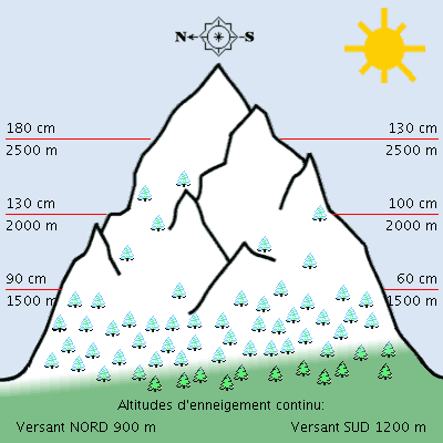
They were excellent, with layers of snow mostly above the average mid-March and locally close to these averages. The snow started at low altitude in North shaded slopes, and around 1400 m in southern steep slopes sunny. There is, around 1200 m: 0 to 150 cm depending on the mass, exposure and slope, to 1800/2000 m: 100 to 200 cm. The lower limit of snow skiing varies between 800 and 1600 m.
The snow surface is crusty and moistened by the morning regel below 1200/1500 meters north steep slopes to over 3000 m in southern steep slopes sunny, elsewhere it remains cold and light, little consolidated 20 to 50 cm or more or less hardened by the wind, especially the tops of massive Bauges senior interior. Then humidification increases during the day, especially in exposed sunny slopes of South-East South-West.
STABILITY Snowpack:
PLATE WIND and natural activity. The thick layer of recent snow settles slowly, more quickly in the sun. It still holds plates and large accumulations sometimes formed by the winds from west to north with gusts up strong temporarily lower valleys. From snowplough moderate to strong North West and sometimes East, is still observed today in altitude.
The sub-layers of angular grains of type faces planes or small crusts regel do not grip the rest of the snowpack. Several accidental releases of friable plaque by skiers or snowboarders are still reported today in North and East exposure between 2000 and 3000 m.
The risk of accidentally cause an avalanche crossing skiers or snowboarders or snowshoes remains strong in all massive. A small surcharge as the passage of a single skier can be enough to drop a plate or surface friable hardest peaks of mostly senior Bauges massive interiors.
Overload greater or lesser extent as the passage of several skiers can trigger an avalanche of plate more or less voluminous mostly above 2000 m and in particular the slopes undergoing somewhat the effect of solar radiation as the exposure to North West North-East or the leeward slopes as the exposure to South East.
In addition, after freezing at night, lower than the previous days, gentleness and good sunshine accentuate the humidification and promote natural, more frequent and larger throughout the day.
Surface flows and avalanches, snow more or less recent wet and heavy plate or friable, will occur just all altitudes, especially in steep sunny especially exposed to the east and south-east and then to South and South-West and the West.
Avalanche background may also occur in steep grassy or rocky slabs mainly below 2500 m. Some of these avalanches can be quite large. And evolution of skiers can promote the flow of the snow more or less onerous.
TREND LATER RISK:
Slightly down Sunday. Météo France updates this newsletter every day to 16h.
Weather forecast
Status and trends Spring, mild on the night of Saturday to Sunday. Serious risk of avalanches in all directions.
(tomorrow) Saturday March 14:
The remaining high temperatures, the freezing night is already less convincing below 1500m. The high cloud does not interfere in the morning but take the thickness of the afternoon in the North and the visibilities become poor night in the 2500m.
pressure 1022 mb plainebassin in Grenoble: 2 / 15 ° C, low wind to 1500m above ground: 5 ° C, low wind-> NW / 6 noeuds1 knot = 1.852 km / h = 0.51 m /s
3000m above ground: -1 -> -4 ° C, wind knots NW/17 iso 0 °: 2800 iso -10: 4300m
Sunday 15 March:
It may even fall a little drizzle at low altitude in the north until mid-morning while the dawn the sun will shine above 1500m but the wind will take over the force with a certain cooling.
pressure 1025 mb lowland: 6 / 12 ° C, wind knots NNW/5-9 to 1500m above ground: 2 -> -1 ° C, wind NNW/8-> NE/14 knots 3000m above ground: -4 -> -8 ° C, wind Nord/22-> 38 -> (night) NNE/18 knots 0 ° iso: 2100 -> 1400 iso 10: 4200 -> 3400m
Monday March 16:
Fine weather still mild with rotation of the wind in the East in sharp decline. pressure 1028 mb lowland: 3 / 14 ° C, wind East / 6 knots by noon to 1500m above ground: 0 -> 4 ° C, wind ESE / 8 knots in the morning 3000m above ground: -7 -> -2 ° C, wind ENE/17-> 10 knots iso 0 °: 2100m iso 10: 3500 -> 4600m
Tuesday and Wednesday
Mostly hot, kissing represent at year end.
.


