

Tips and Conditions - April 1st 2009
This weeks tips and snow report from Henry.
Report from Dan and Henry Last Friday
I skied quite a bit with Dan Egan and his Ski Clinics groups last week here in Val d'Isère. So this week I asked him to do the snow report (I add in a couple hunches I have for the next few days at the bottom):

The Skiing in Espace Killy has been a season worth of snow types in the past seven days! The week opened with chalky snow on the north faces and hard firm frozen ribbed snow elsewhere. Wins and cool temperatures key the snow from transforming and on Wednesday the storm finally arrived and the high pressure that had plagued the French Alps finally buggered off.
The storm dropped a much needed carpet of fresh snow at all elevations. It appears that more snow is on the way for the weekend so prepare to call in sick for work and plan on great skiing well into next week.
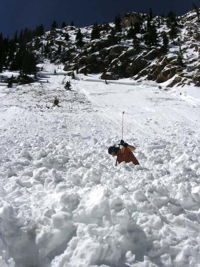
PLEASE remember that the snow is sitting on very firm and slick old snow that was frozen. So small pockets of activity are being reported from Chamonix to Val D Isere (several accidents have been reported). Watch out before you jump into a line of fresh snow - if you're good enough, cut the slope and, no matter what, pick an Island of Safety for an escape route. Just because there are tracks and your friends have skied doesn't mean the slope won't slide. Take responsibility for yourself and use precaution. As an old Val D Isere local once told me, Slowly, Slowly, don't rush the mountain!
Be safe and have fun!
Report from Henry last night
I just got my head around the forecast. in sum looks like over a metre along the border with - half that around Val/Tignes and a small fraction of that border total once you get 20 km+ away from the border. All that snow is going to fall from now until Friday morning. Mt echo is published on Friday pm - the problem is that it is supposed to be very sunny from Sunday on: which means spring snow cycles...
For now this is what is forecast for Savoie and most of the Northern Alps - Tues to Weds: 10 cm for Eastern Savoie (30 on the border) winds gusty on the border. sunny on weds except on the border where precip will continue. - Weds to Thurs 15-50cm for much of Savoie - closer to the 50 cm towards eastern Savoie (and up to 70 cm along the border) winds not to hard but gusty along the border from east to south. -Thursday (day) 10 to 30 cm more on the border - light snowshowers elsewhere in Savoie - Friday/Saturday very light snow/cloudy with some clearing esp on Saturday - Sunday to Tues sunny spring weather
SPRING SKIING report.
Good from Sunday Understand the 'melt-freeze cycles' and have fun with spring skiing! Off-piste spring skiing is one of the best things that the Northern French Alps has to offer. With lift access to all slope orientations: north, east, south and west, you can get on it with little effort.
Melt-freeze Cycles
Once the new snow melts during the day and then freezes at night (1 melt-freeze cycle) a few times in succession after a snowfall, the top snow layer begins to form a crust that gets deeper and stronger after each melt allows free water to drip down and re-freeze during the night. Any given 'melt-freeze' layer becomes stronger with each cycle of melting and freezing due to the deeper penetration of each melt during the day, which then adds more depth to the potential frozen layer at night.
If untouched, the top of this frozen layer is smooth and solid first thing in the morning, then it becomes progressively softer as the warm sun and increased temperatures melt it as the day goes by. This process starts on east faces because they get the sun first thing in the morning, then south, then west (north faces at 2500 metres don't normally get a melt freeze layer on them until late April due to lack of sun). For good skiing!
The trick is, after a couple of good melt-freeze cycles have created a solid layer on a slope, you need to get on that slope when the snow surface is smooth and solid with only 2 or 3 cm's of soft melted snow on top (these are generally slopes that have been in the direct sunlight only for an hour or so e.g. an East facing slope at 9 or 10). Then you need to get off those slopes when the snow surface begins to get too soft and mushy or you'll start breaking through, which is dangerous for your knees. AND the slope may be unstable due to all the melting - then avalanches can be a problem.
In summery.
After a solid melt-freeze layer has formed and there has been a good melt during the day, it needs to freeze well the night before; the ideal is a cool clear night with minimums of -2 degrees (or lower) at 2000 m. This will allow the melted parts of the layer to freeze solid again from that altitude up. Then, in the morning, you look to get on the east facing slopes first thing, 9 AM, because the sun rises in the east and therefore those slopes get the sun first. Then you move to south facing slopes, then west. Do this right and get some of the best skiing of the season.
Aside from a night that is not cool enough, the only thing that gets in the way of great spring skiing is the nasty ruts in the snow that people leave behind because they either ski spring snow slopes (slopes that get lots of sun in spring: E,S and W) before the melt-freeze layer has formed or they ski the slopes too late when they are too soft and mushy.
Tip of the week:
If you have any questions about the timing of good spring skiing, just ask any off-piste guide or instructor around town. They will be happy to explain because their quality of skiing depends on people skiing it right!
Have Fun, Be Safe! - Henry and the HAT Team.
See Henry's Avalanche Talk for the events this week!
Avalanche safety bulletin
N73310311
BULLETIN FOR ESTIMATING THE RISK OF AVALANCHE
de SAVOIE valid outside of marked trails and open FOR WEDNESDAY, 1 APRIL 2009 (written on Tuesday, 31 March)
ESTIMATE OF RISK UNTIL WEDNESDAY EVENING:
MAURIENNE UP: RISK MARK - Level 3 On BAUGES, BEAUFORTAIN, VANOISE, and MAURIENNE TARENTAISE HIGH: LIMIT RISK - Level 2 evolving RISK MARK - Level 3 WEATHER OVERVIEW UNTIL WEDNESDAY EVENING: Degradation in Haute Maurienne and locally on the southern Haute Tarentaise with rainfall more or less regular; limit rain / snow to 1600/1900 meters. Elsewhere, passages of high clouds and some wind gusts.
0 ° C isotherm between 2000 and 2400 meters. Wind General to 3000 m: SOUTH EAST IS 30 to 60 km / h.
Snow conditions:
The snow is still good for the season but with a limit now ski around 1200/1600 meters. There are thickness of 70 to 150 cm from 1200 to 2000 m locally more than 200 cm (Bauges Beaufortain, Haute Maurienne).
On the surface, the conditions spring move again until 2000/2500 m with crusts in the morning then regel humidification more or less important over the hours. Elsewhere, snow surface remains locally drier and lighter if it is not compacted or hardened by the wind at high altitude (snowplough of South East observed since Monday).
STABILITY Snowpack:
NEW PLATES AND WET SNOW AVALANCHE
In Haute Maurienne and locally in the Tignes / Val d'Isere snow expected above 2000 m (10 to 30 cm) and the winds of South East to develop new surface instabilities that need more great caution. Indeed, the overload of one skier may be enough to get the new plates in North West exposures. Some attrition is also possible steep but surely with rain below 1900 m with an already heavy snowpack. An avalanche taking any snow up can occur.
On all the other mountain, after an regel undoubtedly correct, the stability conditions will deteriorate with the resumption of wetting. Slides and avalanches are some new danger, especially in the afternoon, including one or two larger (bottom plates Bauges, Beaufortain for example), in the well exposed slopes (south-west to south-east) but not only.
The evolution of skiers in the snow may become heavy facilitate its flow. They also still some instability associated with surface winds and a sometimes fragile (recent snow layer advanced type of flat faces). We must remain wary, particularly over 2200/2400 m, because the probability of triggering these instabilities with the overload of one or more skiers is not negligible in North East side.
TREND LATER RISK:
Stationary or increasing in Haute Maurienne with new precipitation (rain below 1800/2000 meters.
Weather forecast
Issued Tuesday, 31 March 2009, 20:23
Status and trends
With this scheme is persistent, the sky has been cloudy this afternoon by the Southeast, and half south-east of our area should be more cloud even wet for 48 hours.
Tomorrow Wednesday April 1st:
Precipitation crowd on the slopes in Italy, causing our later time under wet and windy but quite warm (foehn). The sky will be clear to the North-West and South-East where we can expect some precipitation (South Oisans High Maurienne) more intense in the evening with snow from 2200m.
pressure 1012 mb plainebassin in Grenoble: 8 / 16 ° C, wind east / 5 noeuds1 knot = 1.852 km / h = 0.51 m / s decreasing to 1500m above ground: 5 ° C, wind ESE/8-> East / 4 knots 3000m above ground: -4 ° C, wind ESE-> ENE/14-> (night) Est/17 knots iso 0 °: 2300 iso -10: 4000m
Thursday April 2:
The situation does not change much: still precipitation on the slopes Italian filled with snow in France in 2300.
pressure 1012 -> 1016 mb lowland: 10/16 ° C, little wind to 1500m above ground: 5 ° C, wind east-> SSE / 5 knots 3000m above ground: -4 ° C, wind Est/16-> 12 knots iso 0 °: 2300 iso -10: 4100m
Friday April 3:
The wind will move to the South then stop completely. Night Coverage clouds should break up in the morning to make room in the afternoon to scattered cumulus providers ephemeral Giboulées..
pressure 1017 -> 1022 mb lowland: 10/16 ° C, little wind to 1500m above ground: 5 ° C, wind south / 6 knots diminishing 3000m above ground: -6 ° C, wind knots diminishing ESE/10 iso 0 °: 2100m iso -10: 3800m
Weekend
Beautiful warm weather with no wind
.
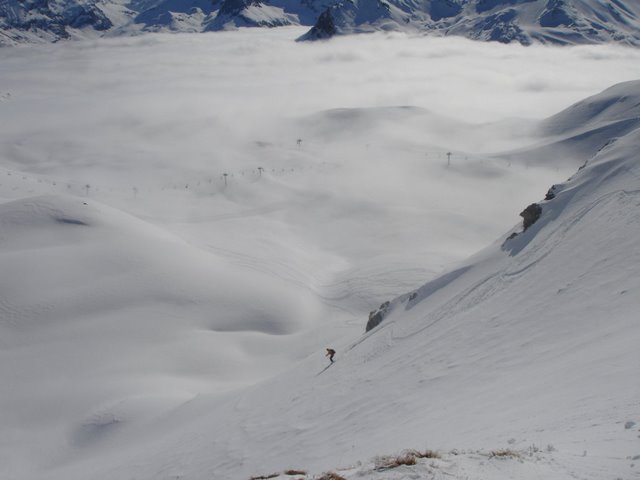
Photo of the week - Great day above the clouds
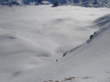
When I got up this morning (March 30)it was grey, cloudy and overcast. When I set out this morning with my group it was grey, cloudy and overcast, but when we got above 2400 metres it was bright blue and fresh snow was everywhere. We skied off piste in several cm's of compact fresh snow all day starting in Tignes then back over to Val d'Isère, the clouds cleared later in the day too - it was awesome!
Sounds like nice weather again tomorrow then Weds will be covered and snowing around the Italian boarder then clearing gradually with temps getting unseasonably high at the end of the week.


