

First snow report from the 2009/10 season!
Avalanche Bulletin from Meteo France
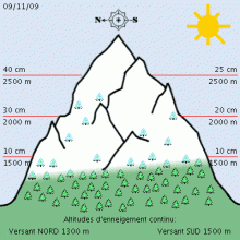
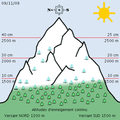
SNOW AND AVALANCHE INFORMATION de SAVOIE
(valid outside of marked trails and open) written Monday, November 9, 2009 from reduced information.
SNOW CONDITIONS:
Good early winter with snow lines to 1300/1500 meters. Snow depths in Beaufortain: 15/25cm about 1700 meters and 50/70cm from 2200 meters.
Snow depths in the Tarentaise and Maurienne: 15 to 30cm up to 2000 meters and 30 to 60cm high. Thanks to the recent retour d'Est there is "very good snow in Haute-Maurienne (border) with 40/50cm from 2000 meters.
ESTIMATE OF RECENT SNOWFALL:
The snowy weather of Saturday, November 7 brought 5 to 15cm to 2000 meters in general, 15 to 25cm in Beaufortain with a rain-snow limit towards 1000 meters and winds strong enough to Southwest (gusts 50/70 km / h from 2500 meters).
A "back East" took place Sunday, November 8th affecting mainly the Haute-Maurienne (area Bessans-Bonneval) in 2000 with 20cm and 30cm meters to 2700 meters. Winds of North-East were weak (gusts 30 km / h).
STATE OF THE SNOW THIS Monday, November 9:
Below 2200 meters, a layer of fresh snow lies on a sub-layer often hardened. Snowpack generally stable enough. Some bottom plates occurred in steep, especially later in South Beaufortain. Above 2,200 meters thicker snowpack and more winter. The recent snow based on sub-layers often solid (little flat faces ..).
The first accumulations are present, however (30 to 50cm thick) but stability still seems asssez good. In Haute-Maurienne, a situation may be more unstable with the latest 30/40cmqui based on several thin sublayers more fragile. Suspicion if the presence of accumulations of recent snow.
TREND FOR THE NEXT DAY:
Little snow expected until Thursday but still high cloudiness and cold weather. The snowpack should not change with a slow settling of the first accumulations (risk reduction) and probably an early transformation of the cold snow (formation of the first sub-layer fragile possible).
This information will be renewed no later than Thursday, November 12 (Thiery Arnou) Weather Forecast for Northern French Alps Situation and Prospects
The warming trend will continue. No further rainfall expected that a few drops Thursday morning in the North.
Wednesday, November 11:
The sun will always dominate with the wind Northwest elevation not preventing a start warming. pressure 1011 mb plainGrenoble area: 2 / 9 ° C. Wind Nord low to 1500m above ground: -2 -> +2 ° C Wind NNE / 7 nodes1 knot = 1.852 km / h = 0.51 m / s weakening to 3000m above ground: -8 -> -3 ° C, wind Nord/12-> NW/20 knots iso 0 °: 900 -> 2200m iso -10: 3500 -> 4100
Thursday, November 12:
Low clouds and how the night will return north with some even limited rainfall a few flakes over 2500m, then the weather will become commonplace in the South. Pressure 1012 -> 1016 mb plain: 3 / 13 ° C, low wind to 1500m above ground: 2 -> 5 ° C, wind Ouest/10-> SW / 8 knots to 3000m above ground: -2 ° C, wind WNW/22-> Ouest/20 knots iso 0 °: 2300m iso -10: 4300 -> 4600m
Friday, November 13:
Cloudy moist and soft enough so that there is no precipitation we even enjoy episodes of sun in the afternoon. pressure 1017 mb plain: 6 / 15 ° C. Wind SSW-> SSE / 5 knots to 1500m above ground: 5 -> 7C, wind SW/11-> (night) Sud/16 knots to 3000m above ground: -3 -> 0 ° C, wind knots WSW/20 iso 0 °: 2700 iso -10: 4300-4600m
Weekend
Wind South-West especially Saturday with a thick layer of high clouds impairing visibility on snow. Best Sunday.