

Snow Report November 26th 2009
This weeks snow report from Henry
The French weather forecast promises an apocalyptic degradation in the weather! Meaning lots of snow which is good news.
Recent avalanche activity has been due to wet snow slides below 2500m. However next week this will all change. The cooler weather will refreeze any wet snow and consolidate the base. The greatest risks will be high up above 2700m where the bulletin reports signs of a weak layer of depth hoar.
But with the scale of snowfall predicted the levels of risk could go up markedly by Monday or Tuesday. the other feature promised in the weather is a 180 degree switch in wind direction, this means snow will be transported in one direction and then the other which will make interpreting the conditions more difficult. We will keep an eye on whether this happens.
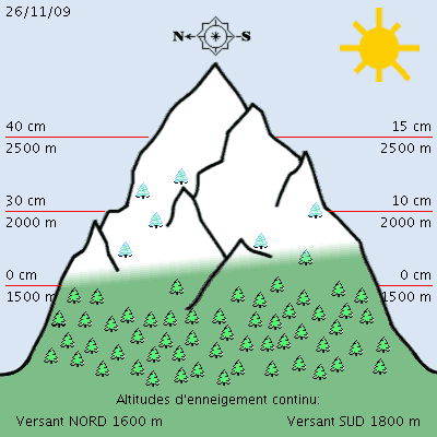
Snow Report
The base looks good above 2000m. The snow is forecast initially to fall above 1800m and then from about 1000m during next week. So all very promising.
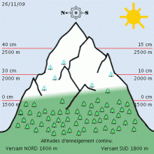
The recent warm weather initially destabilised the base, but as it gets cold and freezes back. This base should be good below 2700m. But above that there are signs of a weak layer of depth hoar The risk next week will depend on the quantity of new snow that falls see blog report and bulletins.
Avalanche Bulletin from Meteo France (N73261111)
SNOW AND AVALANCHE INFORMATION de SAVOIE
(valid outside of marked trails and open) written Thursday, November 26, 2009 from reduced information
SNOW CONDITIONS:
The snow began between 1500 and 2100 m or 1300 m locally in northern steep slopes. Snow depths can be achieved: Bauges in 5 cm at 1800 m, 15-30 cm at 2000 m; in Beaufortain: 10 cm at 1800 m, 20-30 cm at 2000 m, 30-50 cm at 2500 m; Vanoise in: 5 cm at 1800 m, 5-15 cm at 2000 m, 10-30 cm at 2500 m; Maurienne: 5 cm at 1800 m, 5-15 cm at 2000 m, 5-40 cm at 2500 m; Haute Maurienne: 5-20 cm at 1800 m, 5-40 cm at 2500 m; Haute Tarentaise: 5-30 cm at 1800 m, 15-50 cm at 2500 m; around 3000 m, they can reach 20-80 cm. HAT Note: Val d'Isere Tignes is in Haute Tarentaise
ESTIMATE OF RECENT SNOWFALL:
Between Monday 23 and Tuesday 24, snow fell, locally to 1800 m: 20 cm south of Haute Tarentaise and 5-10 cm in Haute Maurienne of snow partially humid above 2200 m, it has been dropped: 20 -30 cm of dry snow in Bauges Beaufortain 50 cm, 5-35 cm Vanoise Maurienne 5-20 cm, 5-15 cm in Haute Maurienne, 15-40 cm high mountains.
Last night and this morning Thursday, 26, has been dropped less than 5 cm of dry snow above 2,400 m, mainly Beaufortain.
STATE OF THE SNOW
Thursday, November 26:
Monday and Tuesday, the rain-snow ranged between 1100 and 1800 m. The snowfall was accompanied by strong winds from southwest to west summits Bauges senior massive interiors, and also temporarily Northwest lowest particularly in Upper South Haute Maurienne and Tarentaise, forming accumulations few more or less thick in sheltered sectors and plaques wind more or less hard.
Wind South to South West was still blowing strong on the peaks Wednesday Bauges senior massive interiors, with a little edge of Lombardy Piedmont, and the plow has been observed at least on the high mass Vanoise forming some new plates surface. On the other hand, good sunshine and the isotherm 0 ° C to 3000 m could promote surface wetting and spontaneous avalanches of some wet snow or avalanches in steep southern slopes. Last night and this morning Thursday, low rainfall have circulated mainly in Wallows Beaufortain with a rain-snow limit towards 2200 and 1700 m and a wind from south-western moderate mountain.
This snow is based on recent internal layers of moistened and then consolidated by refreezing below from 2700 to 3100 m in north slopes and higher slopes in South, but their adhesion is not ensured. Beyond 2700/3000 m north slopes, the inner layers consist mainly of angular grains may conceal strata fragile and some old plates.
TRENDS FOR THE NEXT FEW DAYS:
Low snowfall is expected Friday afternoon with rain-snow limit towards 1500 and 1100 m and wind SW strong enough in high mountains.
Saturday was sunny, a little softer, the wind south-west and west is very high mountain. Sunday, strong winds Southwest Mountain Foehn with Lombardo and lowest rainfall and especially near the Piedmont with snow above 1500 m. Monday, precipitation became widespread and the rain-snow falls around 1000 m. These conditions will aggravate the instability of the surface snowpack.
This information will be renewed no later than Monday, November 30 (Thiery Arnou)
Weather Forecast for Northern French Alps
Situation and Prospects
The moon shines tonight and the atmosphere will be tolerable to the degradation Sunday which will take a look apocalyptic Monday.
HAT note: this rather strange translation of the weather forecast means there will be a lot of snow on Monday and quite a bit before that on Sunday.
Friday, November 27:
The sky cleared enough at night and the morning will cover the North West with rather low rainfall in the north in the afternoon with a little snow from 1800. The strong westerly winds aloft will subside during the day. Pressure 1018 -> 1015 mb to 1500m above ground: 1 / 4 ° C Wind WNW / 9 knots to 3000m above ground: -5 -> -8 ° C, wind Ouest/28-> 18 knots iso 0 °: 1700-2000m iso -10: 4200 -> 3300m
Saturday, November 28:
Generally clear at the end of the night while maintaining a west wind moderate altitude. Relatively low temperatures despite the sun. pressure 1016 mb to 1500m above ground: 2 ° C Wind NW-> SSW/8-> (night) Sud/16 knots to 3000m above ground: -8 -> -5 ° C, wind WNW/24-> SW/30 knots iso 0 °: 1600/1900m iso -10: 3300 -> 4000
Sunday, November 29:
A strong wind from the south overnight pushes air masses Mediterranean causing precipitation from the first 6 hours. The precipitation will intensify throughout the day with an extra disturbance that may cause thunderstorms. Pressure 1014 -> 999 mb to 1500m above ground: 2 -> 5 ° C, wind knots Sud/20 to 3000m above ground: -6 -> -3 ° C, wind SW/32-> South /45 nodes iso 0 °: 1600 -> 2200m iso -10: 3900m
Monday
An unbelievable deluge in a storm from the south will punish us all night and precipitation blithely continue until late next night especially in the North. The snow drifts from 2000m, then on the night of Tuesday, the winds reversed 180 degrees, still vigorous, and with the cooling and refreeze, the latest snowfall accrue from 1000m.


