

Snow report this weekend and past week 04/12/09
Compared to last week the snowline has dropped to 800m. The bulletin reports greater snow depths around Tignes & Val d'Isere, so all very promising.
The recent warm weather initially destabilised the base, but as it gets cold and freezes back. This base should be good below 2700m. But above that there are signs of a weak layer of depth hoar The risk next week will depend on the quantity of new snow that falls see blog report and bulletins.
Avalanche Bulletin from Meteo France
N73031211 SNOW AND AVALANCHE INFORMATION de SAVOIE
(valid outside of marked trails and open) written Thursday, December 3, 2009 from reduced information
SNOW CONDITIONS:
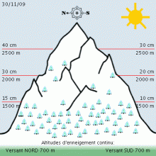
Above 800 to 1000 meters, is all white with the recent snowfall. By cons, skiing seems possible that from 1600/1800 meters North Slope and 2000 meters south side with the presence of a sub-layer dense.
Snow depth at 1800 meters: 20 to 40cm 2500 meters: 40 to 80cm
The massive Beaufortain of Tarentaise (Val d'Isère) and part of the Maurienne (Pays d'Arves) currently seem the best snow. In the other mountain, the snow is close to seasonal averages.
ESTIMATE OF RECENT SNOWFALL:
A disturbance force has crossed into our massive night of Sunday to Monday with snow to the valley which continued until Tuesday morning. In the end, he fell between 30 and 50cm Bauges Beaufortain up in the Maurienne (country Arves) above 1800 meters, often between 20 and 30cm on the other mountain. Winds from the South Foehn storm had blown in earlier (gusts over 100 km / h until Valley).
The previous fall was dated 22/23 November with 15 to 30cm in height but the rain had come to disturb the snow to 2200/2300 meters.
STATE OF THE SNOW.
Thursday, December 3:
Below 2200/2300 m, the recent snow based on a snowpack often very dense with the presence of numerous crusts freeze. The stability seems good enough yet, despite some small surface slabs.
Above 2200 to 2300 meters, stability more dubious because the recent snow was deposited on a snowpack that has undergone a major transport snow storm Sunday foehn (wind at 100 km / h). Plates are buried under the snow. The latest formed under the action of wind to North on Monday. Presence of accumulations in many exhibitions, sometimes opposite (North or South). Attention Beaufortain Maurienne or sometimes with thicker plates (cracks up to 50cm).
TENDENCY TO FRIDAY:
A disturbance on Thursday in a stream of south-west, much like Monday, but less active and less wind. The snow will sink quickly to 400/700 meters. It provides 20/30cm on Bauges and Beaufortain 15 to 20cm on the other mountain. Sky charged Friday but little snow.
The snow will be deposited on snow generally little changed (snow stayed cold Saturday - still plastered trees) and with winds not too strong (gust 40 at 60 km / h maximum). The risk of an old slab or higher increases slightly. Natural avalanches are possible during the Falls.
This information will be repeated tomorrow, Friday, December 4 (Thierry Arnou)
Weather Forecast for Northen French Alps
Situation and Prospects
Issued Wednesday, December 2, 2009, 18:58
Precipitation generous tomorrow Thursday, Friday and limited non-existent Saturday.
Thursday, December 3:
The clouds are coming from the west early in the night to 2000m. We will not see the sky until midnight. Rainfall will be already installed in the morning starting from the south where they will be more intense, then they generalize, interspersed with breaks and wind slab frpm the strong south wind and generous amounts of snow above 2000m, while the rain begin to moisten miserably the already heavy snow below.
Pressure 1014 -> 1007 mb
1500m above ground: 1 / 3 ° C, wind SSE/14-> WNW/6-> (night) NNW/10 knots to 3000m above ground: -6 ° C, wind SW/24-> 12 -> (night) NW/20 knots iso 0 °: 1900m iso -10: 3800 -> 3500
Friday, December 4:
A lively night cooling will freeze the snow melted the day before while the treacherously covering a thin layer of with flakes above 1000m. The north wind will increase, inhibiting the rise in temperatures, and snowfall will continue fairly low at least morning between 800 and 2500m, but the wind will not fail to carry snow from yesterday to complete the random wind slabs.
Pressure 1007 -> 1003 -> 1012 mb to 1500m above ground: +1-> -3 ° C, wind Ouest/7-> Nord/22 knots to 3000m above ground: -7/-11 ° C, wind WNW/18-> Nord/28-> (night) 20 knots iso 0 °: 1600 -> 1000 -> (night) 600 iso -10: 3300 -> 2800 -> 3500 iso -20: mini 4300m
Saturday, December 5:
Persistent northerly winds, mostly sunny in the morning with sharp increases temperatures and incitement to destabilise wind slab. Pressure 1023 -> 1016 mb 1500m above ground: -3 -> +3 ° C, wind Nord/15-> NNW/10 knots 3000m above ground: -6 -> -2 ° C, wind NW/25-> 20 knots iso 0 °: 600 -> 2400 iso -10: 3600 -> 4400
Sunday, December 6th
Time and mild west wind in the mountains. Filtered sunlight and visibility is variable.
See www.henrysavalanchetalk.com for more info on these practical short courses.


