

Hat Snow report Feb 6th 2010 & avalanche bulletin.
HAT Snow Report Feb 6th, 2010
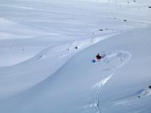
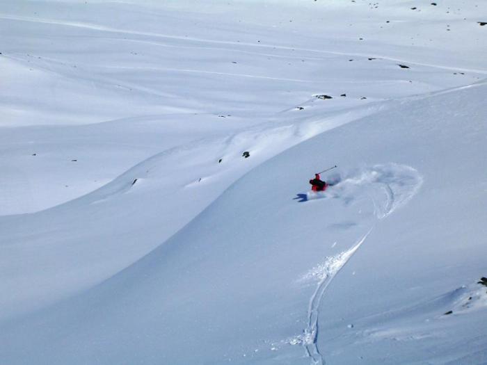
Wind and snow have dominated the weather over the past week – leading us to go for soft snow in areas sheltered from the wind. Looks like more snow coming. Plenty on Tuesday/Wednesday!
Snow Quality and Stability
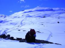
There’s been some really good snow this past week in areas sheltered from the strong winds, but we’ve all been paying keen attention to a couple weak layers that have been evolving due to the very cold temperatures of early this past week and last week.
Clues regarding these weak layers have been numerous: numerous reports of ‘whoomphing’ (which is the thunderous sound of a weak layer collapsing under a new layer of snow) over the last week, flagrant weak layers in many places especially on North’ish slopes (obvious in quick snow pits of 50-60cm or less, pisteur’s published snow pit data etc.), quite a few slab avalanche releases and the Météo France Avalanche Bulletins.
You can keep up to date on the recent observed avalanches in Savoie: natural, artificial and accidental; as Méteo France Bourg St Maurice has been reporting/listing them most days on the official avalanche bulletins (you can access a translated version of this via www.getoffpiste.com).
Tips for this coming week
Start your day on low angle slopes and think seriously about going on steeper slopes.. or not. Base your decisions on observable facts (like recent avalanche activity, info in the avalanche bulletin..) and talk to the pisteurs - many of them will have just been out blasting. They may not tell you where the best skiing is, but if you can demonstrate to them that you are not an idiot, they will impart valuable information about the snow stability.
Have Fun and Be Safe!
N73040211 - AVALANCHE BULLETIN for the SAVOIE
Valid outside of marked trails and open
For Friday, February 5, 2010 (written Thursday, February 4)
RISK ASSESSMENT UNTIL FRIDAY EVENING:
In Bauges">Bauges and Beaufortain the Lauzière west Maurienne: CONSIDERABLE_RISK - Level 3 moving in day HIGH_RISK - Level 4;
Further east: CONSIDERABLE_RISK - Level 3.
WEATHER OUTLOOK UNTIL FRIDAY EVENING:
Strong wind southwest to south-east overnight heights Bauges senior indoor ranges with Foehn and Lombarde_y the border in the valleys and up Vanoise, and low precipitation. Precipitation generalized and more intense day, with winds of South and North-West temporarily strong enough on the highest ranges of the South Vanoise, Haute Maurienne. Above 2000 m, we expect 15 to 50 cm of dry snow.
Isotherm 0 Ã'° C: about 2500 m but lower on the frontier of Piedmont, and then down to around 1200 m.
Wind General to 3000 m: South-West South-East night 30/60 temporarily 60/70 km / h, south-west to east then north-west during the day 20/40 km / h.
SNOW_CONDITIONS:
The snow is very thick part below 700/1500 m across sectors. There are locally 10-20 cm to 900 m, 50-75 cm at 1200 m, 50-100 cm at 1500 m, 60-120 cm 1800/2000 m except 120-180 cm Bauges">Bauges andBeaufortain. These layers of snow are often below average in early February unless Bauges">Bauges and Maurienne.
On the surface, the snow is cold and more or less densified little consolidated 15-55 cm or more or less hardened by the wind, especially in very high_elevations and lowest in the Southeast Vanoise at the border, or the wetted sun and crusty by refreezing the morning until high altitude steep southern slopes.
STABILITY OF THE SNOWPACK:
INSTABILITY IN ALL will increase range.
With the wind and the nighttime low rainfall expected, this will first be accidental that the risk will involve steeper many directions and altitudes various sectors most exposed those with little remaining sustained action of the sun . One skier can be enough to trigger a plate surface, more or less hard in the most windy areas, more friable elsewhere. In passing one or more skiers, a thicker plate can be stalled or even a floor plate.
Then over the diurnal rainfall, the natural and accidental risks will increase. The new layer of snow does not adhere well to the snowpack. The cast surface and avalanches will occur spontaneously in all ranges and just all altitudes, carrying the snow and sometimes unstable slabs, more or less friable, on which it is based. A fortiori, an additional overhead as the passage of one skier may be sufficient to cause the avalanche. Thus some avalanches can mobilize very large amounts of snow especially Bauges">Bauges and Beaufortain the Lauzia¨re Maurienne in the West where the quantities of fresh snow will be most important.
Below 1800 m, lava flows or avalanches mobilize the wet snow more or less heavy.
EVOLUTION OF THE AVALANCHE RISK:
Steady or slightly down for Saturday but can rise to the Maurienne">HauteMaurienne with the wind.
Weather updates France this newsletter everyday to 16h..
(Thierry Arnou)
Weather Forecast for Northern French Alps
Situation and Prospects
Gray, wind and snow. Heralded by a southern wind already strong, the first precipitation with the South West are imminent.
Tomorrow Friday, February 5:
The precipitation will become more widespread and intensified at night, often weaker on Savoy. After a reduction in trompe-l'oeil in early morning corresponding to a reversal of the strong wind from the north they will resume more beautiful by the West before noon in nursing particularly the Vercors and Dévoluy but everyone will share in early or later.
Around midnight it will be finished. With lower temperatures, the rain / snow will come down from 1400 to 900m and the quantities of snow additional 2000m to vary from 20 to 40cm.
Pressure 1016 -> 1011 mb plain Grenoble area: 3 / 6 ° C wind ESE/8-> NNW/4-> 10 nodes1 knot = 1.852 km / h = 0.51 m / s to 1500m above ground: 0 ° C, wind SE/16-> low-> NNW/20 knots to 3000m above ground: -7 -> -10 ° C, wind SW/20-> 15 -> NW/32 knots iso 0 °: 1400 -> (night) 1000m iso -10: 4000 -> 2900 iso -20: down to 4400m
Saturday, February 6:
High risk of avalanches. Wind North-West will remain strong in the mountains and sunny the morning will be quickly challenged especially in the north where we will review small snowfalls above 1000m.
Pressure 1013 -> 1010 mb plain: 0 / 6 ° C. Wind NW / 8 knots to 1500m above ground: -1 ° C, wind knots NNW/15-18 to 3000m above ground: -10 ° C, wind NW/35-> NNW/25 knots iso 0 °: 1000/1400m iso -10: 2900m iso -20: 4300-4600m
Sunday, February 7:
Fair especially in the morning in the South with weaker wind. pressure 1013 mb plain: 0 / 7 ° C. Wind Nord / 9 knots weakening to 1500m above ground: -3 / 0 ° C, wind knots NNE/15 weakening to 3000m above ground: -8 ° C, wind NNE/20-> 8 -> (night) WNW / 8 knots iso 0 °: 800/1500m iso -10: 3300m
Monday
Fine weather at high altitude, little windy. The cloud layer above the South to 1500 may be welded.
Have Fun and Be Safe!
Off Piste & Avalanche Awareness Talks: Week of 8th February:
Monday (on bad weather days) 15.30 sharp Basic Talk at the Moris in Val d’Isère Weds 18.00 sharp Basic Talk at the Pacific Bar in Val d’Isère You need to show up at least15 mins before the talk to take advantage of the deals on food & drink!
Tickets are €7.50 (one person under 18 per adult free) and includes great deals on food and drinks at each place! Pre-booking on line price is: £6 on www.henrysavalanchetalk.com (if you can’t come to a talk see our on-line talks on the web site)
HAT is taking the Talks on-snow this year for people who want to learn more in Val d’Isère & Tignes!
See www.henrysavalanchetalk.com for more info on these practical short courses.


