

This weeks conditions 08/03/10
The snow has been badly affected by the wind. Look for NE sheltered slopes where the snow has not all been removed by the wind, but remember to go one at a time, this is where the risk is highest.
Avalanche Bulletin from Meteo France
AVALANCHE BULLETIN for the SAVOIE valid outside of marked trails and open FOR WEDNESDAY 10 MARS 2010 (written Tuesday, March 9)
RISK ASSESSMENT UNTIL WEDNESDAY EVENING:
On Maurienne CONSIDERABLE_RISK - Level 3
On the other ranks MODERATE_RISK - Level 2.
WEATHER OUTLOOK UNTIL WEDNESDAY EVENING:
Temporarily cloudy skies with low precipitation essentially limits of Piedmont. Still cold and windy.
Isotherm -10 ° C: from 1200 to 2000 and 2500 meters. Wind General to 3000 m: Easta NORTHEAST 40 to 70 km / h (20 to 30 km / h in a late afternoon).
SNOW CONDITIONS:
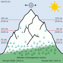
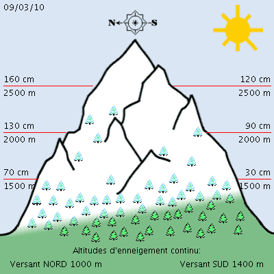
The snow began between 1000 and 1500 meters depending on the show with thickness from 25 to 70 cm in 1500 m and from 60 to 140 cm to 1800/2000 meters occasionally 190 cm Bauges and Beaufortain example.
On the surface, there is usually snow packed, cardboard or hardened by the wind quite a bit of local fresh snow in the vicinity of Mount Tabor and Mount Cenis.
STABILITY OF THE SNOWPACK:
NEW slab ESPECIALLY NEAR THE PIEDMONT
In Haute Maurienne, the strong easterly winds to south with Lombarde_ since Sunday associated with small snow probably more pronounced on Wednesday (20 cm) will promote the formation of new types of instabilities slab more or less thick. The presence of sub-layers or crusty without cohesion (flat faces, snow pellets, particles ,...) makes their bond more than doubtful in many sectors.
The passage of even one skier can be enough to cause a rupture in these weaknesses by stiffness of the slope, especially above 2000 meters including directions in North West. Some attrition is also possible throughout the day.
On the other ranks, the influence of wind from east to south locally to North with the Foehn is also predominant but the transport of snow seems less important because there is little snow mobilizable (5 to 10 cm). However, it is nonetheless likely that new surface slabs are in place or in training, making accidental risk less benign, especially in passing skier (s).
Mistrust, especially over 2000/2200 meters, west to east direction through the North and all along the chain border. The natural activity will remain insignificant with rare cast, exceptionally, a bottom plate steep.
By cons, we must remember that in all ranks, some plate drag in places, maintaining a risk of triggering larger (50 to 80 cm of fracture) in case of heavy load, rather above 2300/2500 meters and North East.
EVOLUTION OF THE AVALANCHE RISK:
Stationary or locally down for Thursday. (Thierry Arnou)
Weather Forecast for Northern French Alps
Situation and Prospects
The gray escaped from Italy has imposed far this afternoon and should locally dissipated into the night.
The cold will slowly decline from Thursday.
Wednesday, March 10:
Cold, wind and dense gray afternoon with the same probability snow along the Italian border.
pressure 1010 mb plain Grenoble area: -4 / 2 ° C, wind NE/7-> 4 nodes1 knot = 1.852 km / h = 0.51 m / s to 1500m above ground: -9 -> -6 ° C, wind NE/12-> 6 nodes to 3000m above ground: -16 -> -13 ° C, wind ENE/22-> 15 -> (night) 5 knots iso 0 °: 0/800m iso -10: 1700 -> 2200m iso -20: 3600 -> 4200
Thursday, March 11:
Provisional sunny morning quickly challenged by the gray up 3000 meters in the afternoon, no wind.
pressure 1013 mb plain: -4 / 4 ° C, low wind to 1500m above ground: -7 -> -3 ° C, low wind NNW / 6 knots in the evening to 3000m above ground: -12 ° C, low wind iso 0 °: 0/1200m iso -10: 2400 -> 2700 iso -20: 4200 -> 4700m
Friday, March 12:
Late night very cold because clear, but the afternoon will be enough disappointing due to a gray and reduced visibility in 2000 to 2600 meters.
pressure 1015 mb plain: -3 -> +7-> 0 ° C, low wind knots to 1500m above ground: -5/-1 ° C, then north breeze / 8 knots in the evening to 3000m above ground: -10 ° C, little wind and Nord/12 knots in the evening iso 0 °: 0 -> 1400 -> 600m iso -10: 2900m
Weekend
Halt to global and back north wind, strong at altitude. Beautiful Saturday in the mountains, more doubtful in 2200m in the afternoon. To be confirmed for Sunday, cold sunshine all day.

